
The academic landscape for Master’s students has shifted dramatically over the last few years. Gone are the days when a simple map and a few data points were enough to impress a university committee. Today, we live in the era of “Big Data”—a world where trillions of data points are generated every second by smartphones, satellites, and IoT sensors. For students in fields like urban planning, environmental science, and logistics, the real challenge isn’t just finding data; it’s figuring out how to layer that massive amount of information onto a Geographic Information System (GIS) to tell a meaningful story.
Navigating the technical hurdles of spatial databases and high-volume data processing can feel like a full-time job on top of your existing studies. Many students realize halfway through their project that cleaning messy datasets takes longer than the actual analysis. If you find yourself stuck at this stage, seeking Assignment help online from experts like myassignmenthelp can provide the necessary bridge to turn complex data into a polished, high-grade paper. This allows you to focus more on the strategic implications of your research rather than getting lost in the technical weeds of data formatting.
The Convergence of Big Data and Spatial Analysis
At its core, “Big Data” refers to the three Vs: Volume, Velocity, and Variety. When you bring these into the world of GIS, you add a fourth dimension: Location. Every tweet, every delivery truck movement, and every temperature change happens somewhere. Integrating these allows Master’s students to move beyond static maps and into predictive modeling.
For a modern assignment, this means you aren’t just looking at where things are; you are analyzing where they will be. For instance, instead of mapping historical traffic jams, a student can use real-time GPS data to predict future congestion patterns based on weather changes or local events. This level of depth is what separates a standard Master’s assignment from a world-class research project.
1. Harnessing Cloud-Based GIS Platforms
In the past, students were limited by the processing power of their laptops. If you tried to run a complex spatial analysis on a million rows of data, your computer might crash. Today, strategies for Master’s assignments focus on “Cloud GIS.” Platforms like ArcGIS Online, Google Earth Engine, and Mapbox allow you to process massive datasets on remote servers.
- Scalability: You can analyze entire continents without upgrading your hardware.
- Collaboration: Multiple researchers can work on the same spatial dataset in real-time.
- Accessibility: Your maps are available on any device, making your presentation much more dynamic.
2. Utilizing Python and Automation
If you are still clicking buttons manually to process data, you are working harder, not smarter. Modern Master’s degree strategies rely heavily on automation. Learning basic Python scripts (using libraries like GeoPandas or ArcPy) allows you to automate the “boring” parts of your assignment.
For example, if you need to extract elevation data for 500 different city coordinates, a script can do it in seconds. This ensures your methodology is “reproducible”—a key requirement for high-level academic success. Professors love to see that you have built a system rather than just performing a one-time task.
3. Real-Time Data and the Internet of Things (IoT)
One of the most exciting strategies for 2026 assignments involves the use of live data feeds. We are no longer limited to census data from five years ago. Students can now tap into API feeds that provide live air quality levels, social media sentiment by location, or live public transit positions.
Integrating IoT data into GIS creates a “Digital Twin” of the area you are studying. This is particularly useful for students specializing in business or management who need to understand supply chain movements. In fact, if your research leans more toward the corporate side of spatial data, getting professional MBA Assignment Help can ensure your business analysis remains as sharp as your technical mapping.
4. Visualizing Complexity: From Maps to Insights
The final stage of any great GIS assignment is visualization. A map with too much data is just a mess. The strategy here is “Data Simplification.” You must learn to use heat maps, 3D extrusions, and temporal sliders (showing change over time) to make your Big Data understandable to a non-technical audience.
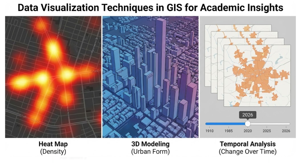
- Heat Maps: Great for showing density (e.g., crime hotspots or population clusters).
- 3D Modeling: Useful for urban planning assignments to show building heights or air flow.
- Temporal Analysis: Showing how a landscape changes over a decade using satellite imagery.
Overcoming the “Data Overload” Barrier
The biggest risk in integrating Big Data with GIS is “analysis paralysis.” Students often spend so much time gathering data that they forget to actually write the paper. To avoid this, follow a strict project timeline:
- Define the Question: Don’t look for data first. Decide what problem you are solving.
- Filter the Noise: Only use data that directly answers your question.
- Analyze & Interpret: This is where the “Master’s level” thinking happens. What does the map actually mean for policy or business?
Why This Matters for Your Career
Mastering the integration of Big Data and GIS isn’t just about getting an ‘A’ on your assignment. These skills are in incredibly high demand in the global job market. Whether you end up working for a government agency, a tech giant, or an environmental NGO, the ability to translate “The Big Picture” into “The Local Map” is a superpower.
By following these strategies—utilizing the cloud, embracing automation, and focusing on clear visualization—you ensure your Master’s degree work is not just a requirement, but a professional portfolio piece that stands out to both Google’s search algorithms and future employers.
Summary Table: Tools for Big Data GIS Assignments
| Tool Category | Recommended Software | Best For… |
| Data Processing | Python (GeoPandas), R | Cleaning and automating large datasets. |
| Spatial Analysis | ArcGIS Pro, QGIS | In-depth geographic modeling. |
| Cloud Mapping | Google Earth Engine | Processing satellite imagery at scale. |
| Visualization | Tableau, Power BI (with GIS plugins) | Creating interactive dashboards for presentations. |
Frequently Asked Questions
What is the primary advantage of combining Big Data with GIS?
It adds a geographic dimension to massive datasets, allowing researchers to move beyond static maps and perform predictive modeling based on real-time location trends.
Why should students use cloud-based platforms for spatial analysis?
Cloud platforms provide the high processing power needed to handle millions of data points, ensuring complex analyses can be completed without relying on limited local computer hardware.
How does automation improve the quality of a research project?
Using scripts to handle data extraction and cleaning reduces manual errors and ensures that the research methodology is consistent, transparent, and easily reproducible by others.
What is the best way to present complex spatial findings to a non-technical audience? Focus on clear visual tools like heat maps for density, 3D models for physical structures, and time-sliders to demonstrate how geographic patterns evolve over specific periods.
About The Author
Min Seow is a dedicated academic researcher and education consultant with a passion for bridging the gap between complex data and student success. Representing myassignmenthelp, Min focuses on providing students with the strategic tools and insights needed to excel in high-level university projects.